Bring on Summer
For the road warrior seeking Nantucket’s wilder side…
Off-Roading on Nantucket
By Courtney Hollands
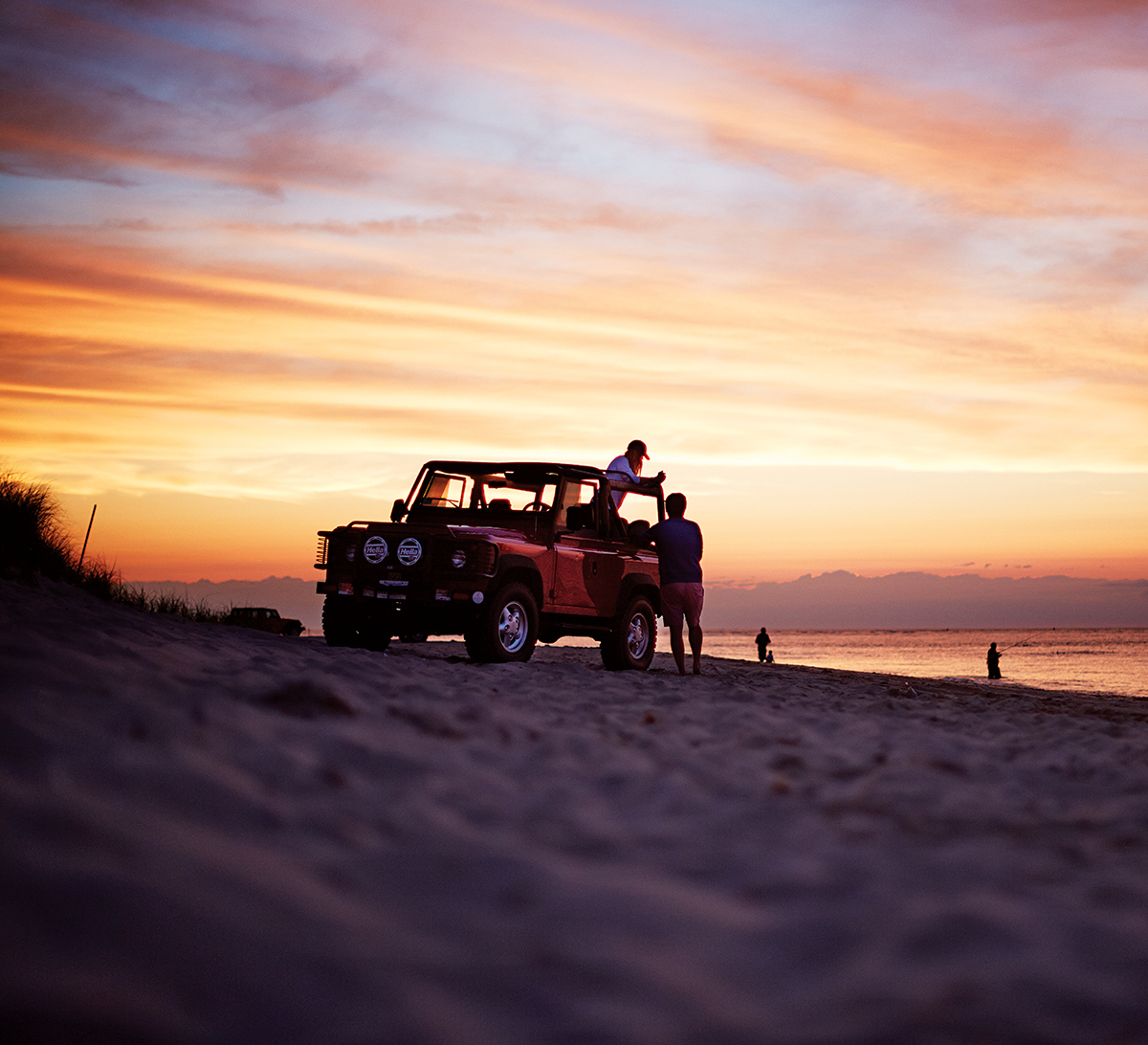
All is quiet as off-roaders take in the glorious sunset on Eel Point. (Photograph by Jonathan Kozowyk)
“Ninety percent of people explore 10 percent of the island,” quips Bob Ruley, of the Nantucket Conservation Foundation, when we stop by the Cliff Road office for maps. How true. My husband and I have been coming to Nantucket for years, but we had never taken the time to explore the island’s wildest nooks and crannies. But now we’re really going to see it all—over sand, off road, and on four wheels.
To get our bearings, we first take a Trustees of Reservations tour around the Coskata-Coatue Wildlife Refuge, the pristine peninsulas that stretch out from the northeast corner of Nantucket like a skinny whale’s tail. Our guide, native Al Souza, rattles off historical facts as we admire the view.
At an air station near the Wauwinet Gatehouse, Souza deflates the tires (between 12 and 15 psi, or pounds per square inch, is recommended by the town) to achieve the perfect squishiness for beach exploration. Constantly pumping and deflating tires is a Nantucket ritual that we get to know well by day’s end.
Then we’re off, bumping along the rutted trails, glistening water on both sides. The thin stretch of land beyond the gatehouse is known as the Haulover, where fishermen once dragged their boats from the harbor to the open Atlantic Ocean. Souza identifies blue toadflax and golden heather, and we spot turkey vultures, oystercatchers, and other swooping fowl with binoculars. “It’s wild—how the rest of Nantucket used to be,” Souza says.
We round Coskata Pond, passing Jeeps and dinged-up pickups plastered with rainbows of permit stickers as we head out to the Galls—its name means “weak place”—a dynamic sand bridge that’s breached from time to time, cutting off access to Great Point. But today we can cross, and the famous lighthouse comes into view, as do rolling dunes and fishermen casting for blues. There are plenty of people and vehicles about, but it still feels untouched and remote, especially when we climb the light and look out over the vast expanse of sun-kissed sea and sand.
When Souza drops us back in town, we pick up a two-door Jeep from Affordable Rentals and head to the mysterious interior, home to hidden forests (hardwood trees that grow in depressions left by glaciers, unnoticeable from afar), moors, and cranberry bogs.
We turn off Polpis Road and take the dirt way to the top of Altar Rock—at 100 feet above sea level, it’s one of the highest points on the island, and affords views of Siasconset and Sankaty Head Light. Avoiding rocks and potholes and dodging the scrubby shrubs encroaching on the narrow road, I’m silently praying we don’t get stuck as we come upon a secluded kettle hole, Gibbs Pond. Hopping back into the car after a photo opp, I spend the trip down Larsen Road craning my neck for a glimpse of my favorite spot on the island: the “Serengeti,” a grassland with gale-gnarled trees and plywood zoo animals between Milestone and Barnard Valley roads.
By now it’s late afternoon, and we head to town to pick up cheese and crusty baguette, as well as smoked bluefish pâté from Straight Wharf Fish Store. We’re en route to the village of Madaket, on the west end of the island, known for its painterly sunsets.
I spread out our blanket and we feast as the sun slips toward the waves. Close by, a group of eight sunburned friends from Connecticut cluster around a bonfire, gulping Bud Lights and toasting marshmallows for Reese’s Cup s’mores. Earlier, they used the flames to roast local clams. The guys were still dripping from a dip, and I follow suit, wading up to my knees.
Dogs race through the shallows, sending shore birds skittering. The view of the sky—awash in glorious purples, pinks, and oranges—is unfettered, and glasses clink when the masterpiece ends.
With toes caked in sand, I drive barefoot back to the access point, where a dusty Wagoneer is stuck, blocking our exit. “Can we get a little push?” asks the driver.
With a nudge from us, she reverses and revs to make it past the sticky stretch. She waves and we start back to town: It all seems like an off-roading rite of passage.
DON’T MISS
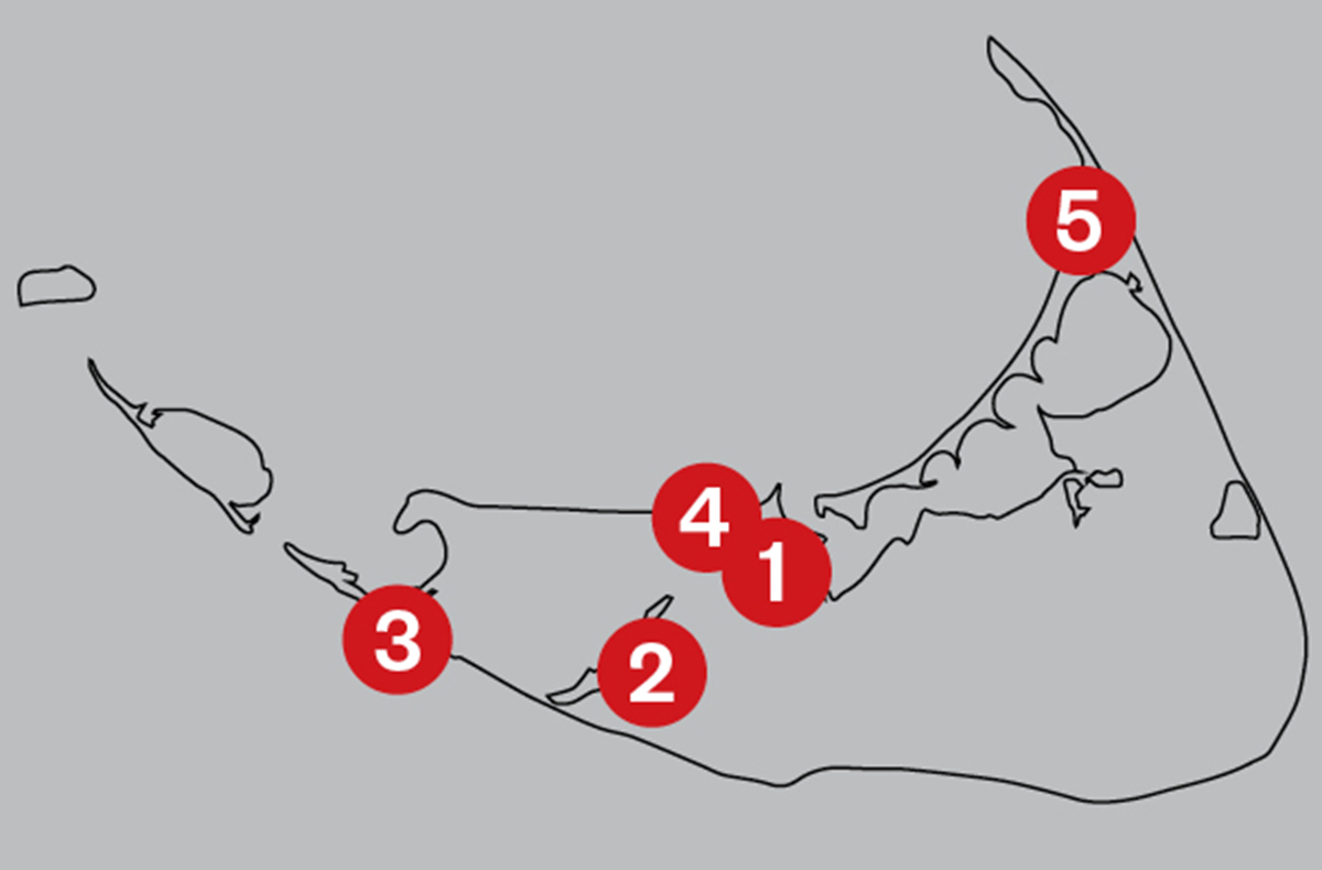
EAT: Smoked bluefish pâté from [1] Straight Wharf Fish Store (4 Harbor Sq., Nantucket) goes well with a six-pack of island-brewed [2] Cisco Brewers beer (5 Bartlett Farm Rd., Nantucket, ciscobrewers.com). Stop at [3] Millie’s (326 Madaket Rd., Nantucket, milliesnantucket.com) for a to-go order of the Altar Rock: chips with salsa, guac, and cheese sauce.
STAY: One of the oldest hotels on Nantucket, [4] Jared Coffin House withstood the Great Fire of 1846, which destroyed more than 200 local buildings (29 Broad St., Nantucket, jaredcoffinhouse.com).
SEE: Explore the [5] Coskata-Coatue Wildlife Refuge’s 16 miles of trails, dunes, coastal forests, and tidal ponds (thetrustees.org). —Julia Rappaport
Nantucket | Martha’s Vineyard | Wellfleet | Provincetown | Our Summer Vacation