BPL Presents ‘Maps from Fiction’ Exhibit
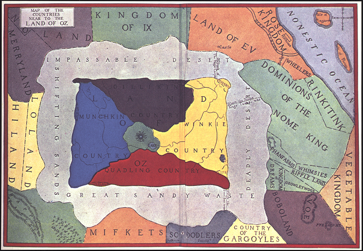
“Map of the Countries Near to the Land of Oz.” / Image Courtesy of the Boston Public Library (Click to view larger.)
Panem. Middle Earth. Hogwarts. These and more fictional settings for popular stories—be them children’s books, YA, or beyond, would be nothing without a sense of place. Over the years, everyone from Frodo to Dora the Explorer have relied on maps to aid in their journeys. And Game of Thrones wouldn’t be the same without its dramatic opening credits map sequence.
To celebrate the connection between maps and fiction, the Boston Public Library opened a new exhibit this week called “Literary Landscapes: Maps from Fiction.” The collection of 40 items from the BPL’s collection include maps that come straight from the actual endpapers from books, as well as maps created by fans that are based on popular stories.
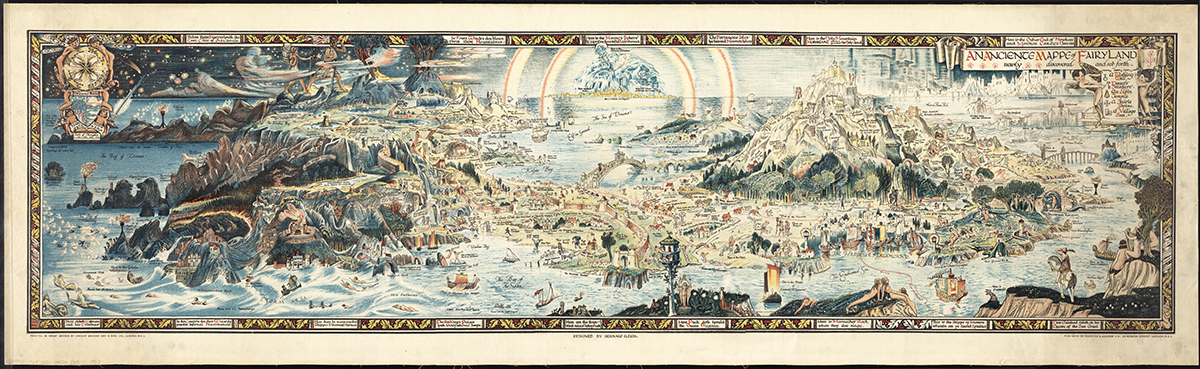
“An Ancient Mappe of Fairyland, Newly Discovered and Set Forth.” / Image Courtesy of the Boston Public Library (Click to view larger.)
“What we’re doing here is using the great books in the BPL’s collection to highlight the different types of maps found in these books. We’re incorporating books from lots of different genres—everything from geographical fiction, to dystopian futures, to high fantasy, and children’s works,” says Stephanie Cyr, who curated the exhibit along with BPL cataloger Lauren Chen. “We hope that readers of all ages can connect or reconnect to maps and books that they see in the show. It’s really fun and we think that it will appeal to a very wide audience.”
The collection includes maps, books, and a surprising amount of pop-up books. They range from as early as a 16th-century copy of Dante’s Inferno—which shows an overview of Hell—to The Phantom Tollbooth, to the maps from Game of Thrones and a fan-made map of Panem from The Hunger Games.
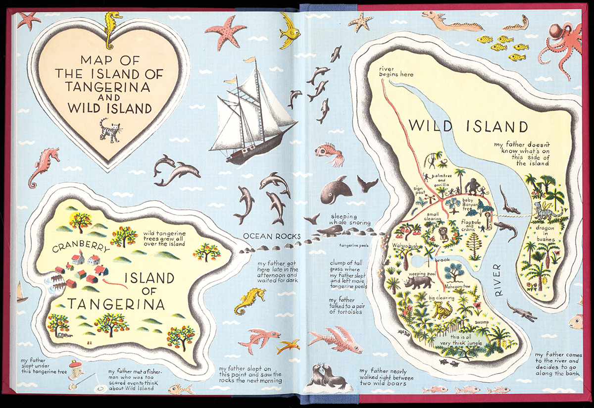
“Map of the Island of Tangerina and Wild Island.” / Image Courtesy of the Boston Public Library (Click to view larger.)
Cyr’s favorite map in the collection is from a 1940s children’s book by Ruth Stiles Gannett. The story follows a boy named Elmer Elevator who is sent by a stray cat from his home island, Tangerine, to Wild Island in order to rescue a baby dragon. “It’s fun, it’s colorful, and it’s very charming,” Cyr explains. “These items really make people smile. It makes me smile.”
The exhibit is appropriately housed in the Norman B. Leventhal Map Center inside the BPL Central Library, where Cyr hopes visitors will learn how important maps are to their stories.
“We here at the Map Center believe that every single map has a story to tell, whether that’s a political story or a historical story,” she says. “But these maps tell the story of characters, and they help explain what the characters are going through, their environment. You can place the story for people—and a story needs to have a place, it needs to take place somewhere. These maps are very important even if they are from fiction.”
“Literary Landscapes: Maps from Fiction” will be on view through October 25 in the Norman B. Leventhal Map Center at the Boston Public Library. For more info, visit maps.bpl.org.