Could Boston’s Urban Ring Be Another High Line?
It is hard not to be impressed with the astonishing, multi-phase redevelopment of an old industrial elevated rail line in New York known as The High Line. It is an expensive, beautifully designed park that snakes its way through the Lower West Side of Manhattan. The High Line is a tremendous success in a part of architecture and design that has proven most elusive to recent generations: high quality design in service of the broad public.
It would be easy to highlight the many ways in which the situation in Manhattan is unique. Real estate values are very high, density is great, the park was created on a whole different plane from the city itself on an abandoned industrial rail line that runs 30 feet above the streets for some 20 blocks. And perhaps most important, the High Line is situated in the midst of one of the most stylistically avante garde parts of the United States, making its elegant but unexpected mix of re-purposed industrial infrastructure, austere contemporary minimalism, rustic landscapes, theatrical view corridors, unique windows on the city, and interactive art spaces all seem like welcome and natural urban amenities.
But there are lots of cities with underperforming urban promenades. Aging rail lines, under-utilized post-industrial lots, and industrial waterfronts are all over Boston, for example. And we, too, could turn our detritus into a wonder.
The road map is called The Urban Ring.
Now, before you run off thinking that this is just another super-expensive transit boondoggle, it’s important to understand that the High Line itself includes no “transit” whatsoever — save the walking and jogging that people do there every day. Instead, the High Line is more like our own Emerald Necklace, the reprogramming of formerly unpleasant parts of the city into new magnets for social activity and development.
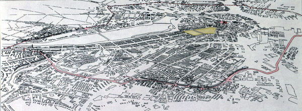
And where would these places occur in Boston? See the drawing below, and you’ll see the basic outline of a new civic, public ring linking Boston, Brookline, Cambridge, Somerville, Chelsea, and Everett into a larger, connected, public sphere. Imagine bike lanes, parks, and public amenities all connected by urban landscape.
 Design: George Thrush; drawing: John McDonald. Click to enlarge.
We have the rail-line that crosses from the Allston yards at the BU Bridge, and all across MIT to Somerville, Chelsea, Everett, and East Boston. This is one-half of the alignment sometimes considered for the Urban Ring. The remainder could be composed of a re-worked “Haul Road” in South Boston, and Melnea Cass Boulevard in Roxbury. A great deal of this land is already available and ready to be designed.
And such a vision isn’t so hard to imagine, nor so expensive to achieve, especially when one considers the increase in tax revenue that the subsequent development would generate. A new Urban Ring, so conceived, would create a regional identity for a collection of small cities and towns that still lack one.
Would such a new system of parks, and development ultimately generate the resources for transit as well? Of course, that is likely too, I think, but in the meantime, we could create a regional amenity that would serve the larger goals of the metropolis for the next generation.


