Curator Finds Map Believed Stolen from BPL a Decade Ago in New York City
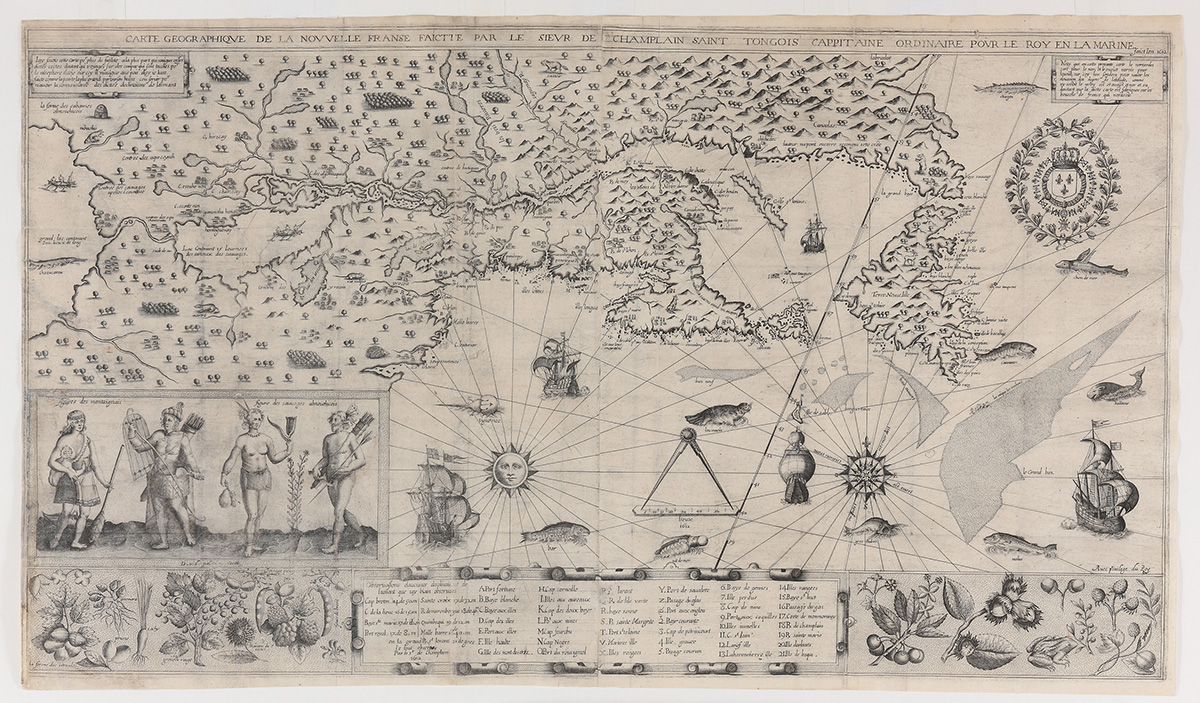
Image courtesy Boston Public Library
The Boston Public Library has recovered a 403-year-old map of New England believed stolen for the last decade, after one of the library’s eagle-eyed curators spotted it at an antique dealer in New York City.
Not long after Ronald Grim joined the BPL’s Norman B. Leventhal Map Center in 2005, he discovered that a map was missing from Les Voyages du Sieur de Champlain, a 1613 book written by explorer Samuel de Champlain detailing his travels in North America, while inventorying the center’s collection. The inventory was prompted by the arrest of admitted map thief E. Forbes Smiley, who confessed to stealing 34 historic maps from Harvard University, Yale University, the New York Public Library, Newberry Library, and the British Library.
Grim found that 69 maps out of BPL atlases and books were missing, including the Champlain map. Earlier this summer, he spotted a map he believed was Les Voyages in an antiques publication, offered at $285,000. Upon comparing it to a digital scan of a 4″x5″ negative of the map from 1992, Grim’s suspicions were confirmed and later verified by a third party conservation expert. Despite some restoration performed since the map left the BPL’s possession, Les Voyages was successfully identified by its “prominent tears on its left side, and a small hole at the juncture of two fold lines just above the middle tear.”
“I was stunned to come across the map, and thrilled to determine it indeed belongs to the Boston Public Library,” Grim said in a release. “I’m proud it’s been returned to its rightful home.” The antiques dealer, who the BPL says was cooperative throughout the whole ordeal, was retained by a third party to sell the map on commission.
“I want to recognize Ronald Grim for his attention to detail and passion for his work at the Norman B. Leventhal Map Center at the Boston Public Library,” Mayor Marty Walsh said in a statement. “The library has one of the nation’s premier map collections, and I’m pleased we have restored this centuries old historic map to the collection.”
“This is a very significant collection managed by the Norman B. Leventhal Map Center. The combined holdings include nautical charts, ornate maps, atlases, and some of the earliest printed maps in the world,” BPL interim president David Leonard said. “I want to thank Ronald Grim for his incredible expertise and thoroughness in identifying this map and taking action to report it. The cultural and educational value of this collection will be all the stronger with its return. This return is a triumph of BPL’s curatorial diligence and early digitization expertise at their best.”
Les Voyages du Sieur de Champlain was Champlain’s first published map. Measuring 17 inches by 30 inches, the map shows New England’s coast, the Canadian Maritime Provinces, and the St. Lawrence River Valley as far west as the Great Lakes, and is adorned with depictions of Canadian flora and native peoples.
You can see the map on display at the BPL’s Norman B. Leventhal Map Center at the Central Library in Copley Square from now until February 29.