Jumpstart Your 2021 Fall Foliage Day Trip Plans with this Interactive Map
If you're craving some outdoor beauty this fall, here's where—and just as important, when—to hit the road.
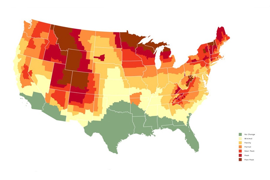
Map via SmokyMountains.com
When it comes to leaf-peeping season in New England, timing is everything. Head up north or out west too soon, and you’ll find seas of boring old green up and down the mountains. Too late, and you’ll have to settle for the doldrums of brown.
Especially in a year that may or may not have us prioritizing fresh air over indoor spaces, the moment to plot out your autumn adventures has arrived.
What better way to aim for the sweet spot than by perusing this helpful interactive map of when foliage is expected to peak this year. It comes to us by way of SmokyMountains.com, a site that promotes travel to the also foliage-dense national park in Tennessee and North Carolina.
The map represents a nation-wide analysis of a trove of weather data, split county by county, on rainfall and temperature, accounting for factors such as average daylight exposure, all of which set the course for how foliage will develop each fall. The study also takes note of historical trends and data outputs from prior editions of the map. It’s not perfect, and Mother Nature can be fickle, but the site says its maps get better by the year. Also, keep an eye on the map as the weeks pass. For the first time, it will be updated in the middle of leaf-peeping season, once foliage trends begin to actual reveal themselves in the leaves.
“After publishing our predictive fall foliage map for nearly a decade, we are quite confident in our data sources, process, and algorithm,” says David Angotti, the company’s founder and in-house stats expert, in a statement. “Our experience combined with a scheduled mid-season update has us especially confident about this year’s predictions. Our goal is that this data- based, interactive tool will increase the number of people that are able to enjoy peak fall in 2021.”
For New England, the map shows the first twinges of color emerging up in the northernmost segments of Vermont, New Hampshire, and Maine by September 6, with peak conditions arriving in those areas by September 27. As of right now, New England will begin to transition into past-peak territory by late October, with the last slivers of peak brilliance slipping out of Southern New England and coastal Maine by the 25th. But, again, check back later for more precision in the later months.
Over at NewEngland.com, which has for many years published a trusty Fall Foliage Forecast, they’ve crunched the numbers on this past year’s warmer than average winter, dry spring, and incredibly wet July, along with an outbreak of LDD moths. Right now they’re predicting an early start to foliage in northern New England, for a season that will be beautiful but short-lived, and a possibly later-than-usual arrival of peak brightness in the southern parts of the region.
So as you’re looking ahead to every photographer and hiker’s favorite time of year, take heed of this interactive map, listen to your local leaf-analysts, and get ready to get out there and explore.