Google Teamed Up With Environmentalists to Track Natural Gas Leaks
Google employees haven’t just been driving around in their Street View cars taking sometimes questionable snapshots of the city’s landscape to add to their Google Maps database. They’ve also been tracking natural gas leaks.
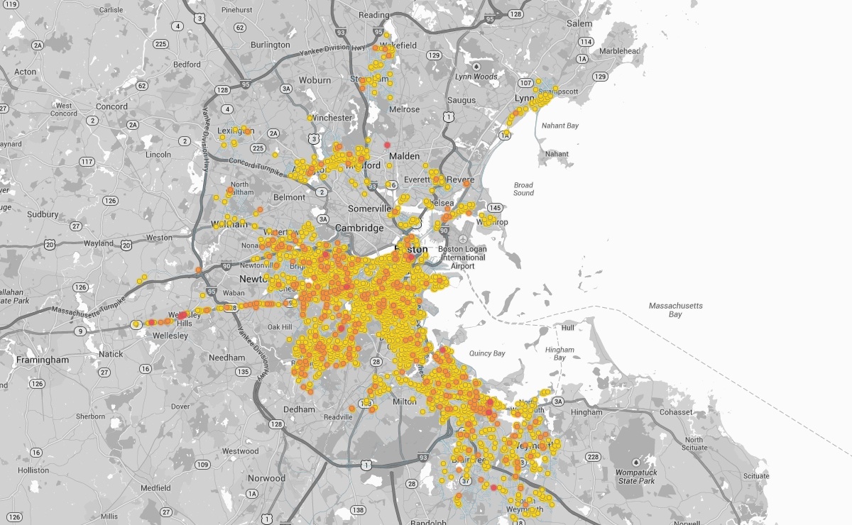
Over the course of a few months in 2013, through a partnership with the Environmental Defense Fund, Google’s Street View vehicles, usually reserved for capturing images of the streets so that people can use them when accessing Google Maps, were picking up information about methane leaking into the atmosphere from Boston’s old, corroded pipelines that run below the roadways.
“Leaks like these rarely pose an immediate safety threat, but the leaking natural gas —which is mostly methane—has a powerful effect on the global climate,” said representatives from EDF about the new pilot program and partnership with Google Earth Outreach.
After compiling data, EDF and Google created a series of interactive maps that pinpoint each location that has a potential leak. They were able to do this by recording the data using “sophisticated methane sensing technology” that was strapped to each Google Street View vehicle. Readings in Boston indicated an average of one leak for each mile that a vehicle traveled, the group said.
Researchers from EDF, a non-profit environmentalist group based out of New York, said they spent two years developing and testing the mechanisms used to track the gas leaks in Boston with the help of Colorado State University officials. Other cities that were part of the experiment were Indianapolis and New York City.
“Environmental quality is an issue that affects everyone. Making this information more accessible can make a meaningful difference in people’s quality of life,” said Karin Tuxen-Bettman, program manager for Google Earth Outreach. “This pilot project is meant to explore and understand the potential for EDF and others to map and visualize important environmental information in ways that help people understand both problems and solutions.”
While the information was released this week, along with the maps, the group said the data might not reflect real-time information because a significant amount of time has passed since they first identified the leaks, and some leaks may have been repaired.
EDF said for Boston, they mapped areas serviced by National Grid, which provides gas to most of the city’s residents. They said National Grid officials were helpful in providing information to the cause so that EDF and Google could match up the information picked up by the mobile sensors with data from the utility company.
“We are taking action, accelerating natural gas pipeline replacement to reduce leaks while enhancing safety and reliability, and this kind of technology and data offers valuable insights,” said Susan Fleck, vice president of pipeline safety for National Grid. “We’ve taken a leadership role on a national level and support initiatives underway to reduce methane emissions.”
Gas leaks in Massachusetts have been a hot-button issue during the current legislative session, and elected officials have pushed for changes to how repairs are handled.
In August of last year, Massachusetts Senator Ed Markey released a study about natural gas leaks, called “America Pays for Gas Leaks,” which claimed consumers pay billions of dollars annually for natural gas that never reaches their homes. He said the leaks, caused by old pipes, don’t only cost taxpayers money, but they also contributes to climate change and can lead to explosions.
The EDF said they will continue their pilot program, and start to extend to other cities around the country, hopefully supplying additional information about how technology can help change the way repairs are handled.