Where to See Native American Petroglyphs across New England
Massachusetts, Vermont, and Maine are home to numerous petroglyph sites.
The Woodland period, characterized by archaeologists as a change from hunting and gathering to subsistence agriculture, began in New England roughly 3,000 years ago and ended just before the European Age of Exploration. While much of that era remains a mystery, the coasts, woods, rivers, and ponds of New England hold fragments of the region’s ancient history, recorded by Indigenous peoples.
One of the ways this history is recorded is through petroglyphs, which are found throughout New England. Petroglyphs are rock carvings; the term is usually used to refer to those made by people from North America. New England is home to numerous nationally registered petroglyph sites, made by a variety of different tribes across historical eras. The engravings depict, among other things, hands, people, animals, and faces.
They all bear signs of the impact of colonists. Intentional alterations to the actual stone render some forever changed, while the colonial suppression of Indigenous history and culture has obscured the meaning of some of these ancient artworks. But these sites are fascinating and important parts of our region’s history, so get out and see them if you can. When visiting the listed locations, be sure to follow any posted signs and adhere to the popular “leave no trace” principles of outdoor ethics, and overall, be respectful.
Bellows Falls Petroglyphs
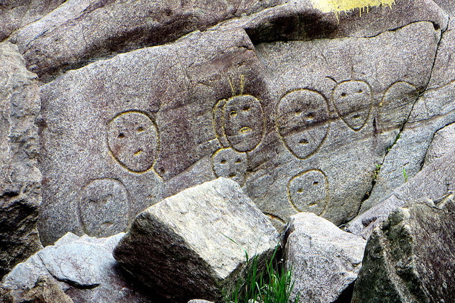
Just some of the Bellows Falls Petroglyphs under the Vilas Bridge. / Photo via Wikimedia Commons.
Below the dilapidated Vilas Bridge in Bellows Falls, VT, is a collection of faces, believed to be made by the Abenaki people, carved into boulders along the side of the gorge. Unfortunately, the age of these petroglyphs has been difficult to determine after a series of misguided attempts at preservation. In the 1930s, Bellows Falls locals had them re-carved to protect them from future erosion. At another point, the petroglyphs were painted yellow to help visitors find and see the inscriptions.
Although the destructive attempts at repair have made them impossible to accurately date, we do know that the faces are at least 200 years old. The first recorded sighting of the petroglyphs was in 1789, when visiting reverend David McClure from Dartmouth described them in his personal notes.
While there have been many different attempts to decipher the meaning of the carvings—McClure thought the faces to be marking the location of evil spirits—the most accepted explanation is that they serve as a waypoint for the dead. In Abenaki tradition, souls move west upon the death of the body. These carvings face west and are found near a burial ground.
These carvings also still hold meaning for contemporary Abenaki. A representative for the nation, Rich Holschuh, told the Keene Sentinel that members of the tribe visit the petroglyphs to communicate with the ancestors that created them.
WHERE: Above the Connecticut River, Bellows Falls, Vermont
HOW TO FIND: Go to the Vermont side of the Vilas Bridge, and peer over the south railing. The petroglyphs are surrounded by yellow paint markers, down by the water’s edge. Those more adventurous can take a rough trail down to the water to take a closer look.
Dighton Rock
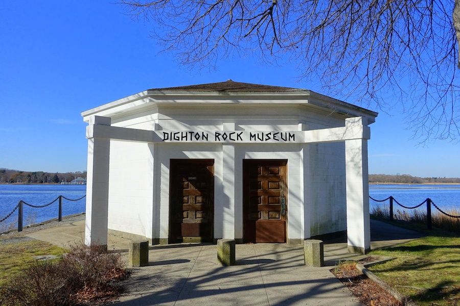
The tiny museum where Dighton Rock now resides. / Photo via Wikimedia Commons.
Like other historical sites in New England with limited recorded information, Dighton Rock has been the subject of New Age-y speculation. Evidence of pre-Columbian contact by the Europeans? Vikings, Phoenicians? Probably not, but that hasn’t stopped people from hypothesizing.
What we do know is that the carvings on the face of this rock—geometric shapes, people, and unidentified writing—are at least 300 years old. As of now, the most likely explanation is that the inscriptions were made by pre-European contact Native Americans, or by the Portuguese explorer Miguel Corte-Real.
The 11-foot high, 40-ton boulder used to lie by the Taunton River, but was moved in 1963 to a tiny museum in Dighton Rock State Park. In 1971, it made the National Registry of Historic Places.
Although much less is known about the carvings of this rock than most others on this list, it is remarkably well-preserved within the small museum. Visits to the museum can be made by appointment only.
WHERE: 3rd Ave., Berkley, Massachusetts
Lakeville Petroglyphs
Lakeville is home to multiple petroglyph sites. A visit to Assawompset pond with an adventurous heart will guide explorers to a number of rocks and boulders with carvings inscribed on them.
Two particular rocks with multiple inscriptions can be found right by the Assawompset Pond, on Bettys Neck, a piece of land that extend into the south side of the pond.
On one of the rocks you can find pecked carvings of a footprint, a teepee, and a handprint, which, according to a Nat Geo Expedition, may date back as far as the Woodland period, between 1000 BCE and AD 1000. The handprint, as recorded by Edward J. Lenik in the Bulletin of the Massachusetts Archaeological Society in 2016, is described as a “pecked left-hand-oriented vertically on the rock.”
Handprints and footprints, in particular, are Native American rock art common throughout North America. While there is no universally accepted meaning for handprints in Native American rock art, Lenik speculated that the “stylized handprint” in Lakeville was made by a shaman to mark the landscape as a sacred site.
After visiting this site, explore the rest of the Lakeville, Middleboro, and Assawompset Pond area to find other petroglyphs. Others of note are Hand Rock and Great Sacred Rock, each a rock canvas for a pecked carving of a hand.
WHERE: Bettys Neck, Lakeville, Massachusetts
HOW TO FIND: Look for two large boulders on the south side of the Assawompset Pond, on the piece of land jutting into the water called Bettys Neck.
Machiasport Petroglyphs
Perhaps the richest area in all of New England for visible petroglyphs, Machias Bay in Maine has multiple locations, each with many panels of ancient Native American petroglyphs.
Three sites of note in this northeastern Maine town are Long Point, Holmes Point and Hog Island. Wabanaki petroglyphs, some of which are at least 3,000 years old, can be found at each of these locations. The Wabanaki were the ancient Indigenous precursors to the modern tribes of Maine. These petroglyphs are traditionally carved with the oldest art seaward on the rock and the most recent closer to land.
The Long Point site is located in the northern region of Machias Bay, on the southern coast of Long Point. In 2013, this site was acquired by the Maine Coastal Heritage Trust, in partnership with the Passamaquoddy tribe. The petroglyphs found there are thought to date back 3,000 years, but also include etching from multiple other eras. The petroglyphs depict anthropomorphic figures and carvings of other animals.
At Holmes Point, on the eastern side of the bay, are rocks with similar carvings on coastal rocks. The third site is Hog Island, a small island that lies between Machias Bay and Holmes Bay. This location has four nationally registered rock art panels. Anthropomorphic figures populate these panels and those on Holmes Point. They are unusually detailed—rock engravings are often drawn in the style of stick figures, but those on Hog Island and Holmes Point feature multiple lines and more fine details, like shoulders and hourglass-shaped bodies.
Kayak tours are available in the town of Machiasport that will take you on a tour of the bay, including stops at many of the petroglyph sites within the bay. Or, bring your own paddle-mobile and find the ancient carvings for yourself.
WHERE: Machiasport, Maine
HOW TO FIND: Take one of the many kayaking tours out of Machiasport or bring a boat, canoe, or kayak and travel along the coast looking for the incredible slices of local ancient history.